
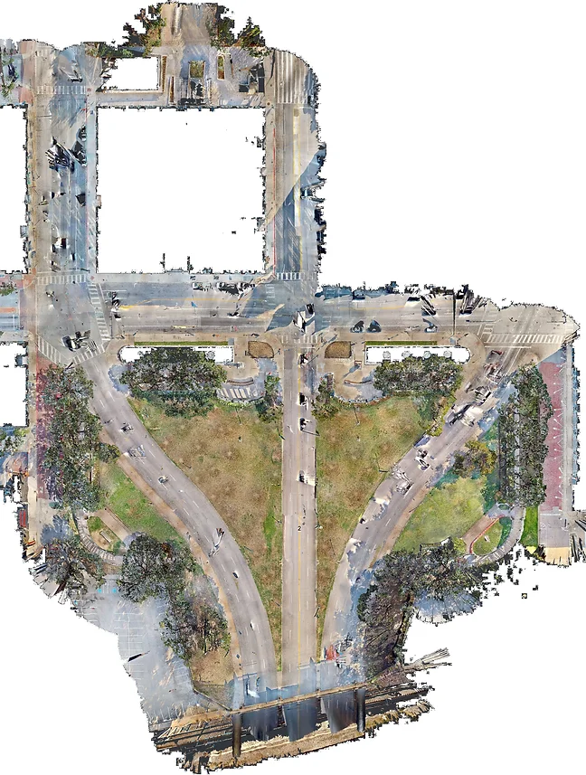
Introducing the CAPA-Auriela Dealey Plaza Digital Twin, a comprehensive preservation and research data set that offers sub-centimeter accuracy. The data set includes LiDAR and drone photogrammetry raw data, with pre-calculated 3D models, making it perfect for a range of research and educational purposes such as ballistic modeling, acoustic modeling, documentary animation, historical reconstruction and much more.
A 60th Anniversary Flagship Project
Mid-2023, CAPA-Auriela Dealey Plaza Digital Twin developer Irving Nestor learned of the talks about changing Dealey Plaza drastically from its current near-unchanged form. As the owner of a film, media and marketing business, he knew he could convert the current physical state of the Plaza into a forensically valid 3D model to preserve the space– as long as there was funding.
That’s when CAPA came in. CAPA (Citizens Against Political Assassinations), an esteemed group of JFK Assassination research devotees and legends of the time, agreed to fund the project when presented with the concept.
Irving’s inaugural presentation of this historic project at the CAPA-Wecht Institute 60th Anniversary dinner.
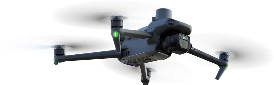
PPK Drone Photogrammetry
Drones allow us to gather spatial data with more positional freedom.
- Roofs, building details, overpasses, etc. are accessible and without interference from ground objects
- High resolution & quality visual spectrum photography
- Large ground coverage
- GPS metadata and PPK base station data increases reference accuracy to the real world and reduces photogrammetry computational load
- 10,409 photos taken of entire subject area at varying altitudes and angles
- Equipment: Mavic 3 Enterprise & RTK Module (using its wide angle lens)
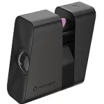
Ground-Based LiDAR Scan
- Trees, overhangs, alcoves, dark areas, etc. are accessible
- 360-degree visual spectrum panoramas taken simultaneous to each scan
- 411 LiDAR scans with 10 million point measurements per scan
- Color calibration cards present in each panorama
- User-friendly web-based previewing via Matterport
- Standardized scan height to the average human male of the 1960s
- Pre-stitched and lighter data set for computation and viewing
- Equipment: Matterport Pro3
FREE PREVIEW VIA MATTERPORT
One-Year Licenses
All our licenses allow you to download the entirety of the CADPDT as many times as needed for one year from receiving your license. It always gives you access to download newer versions within your one-year window as well. After your license has expired, you are still able to use already data from your license as you please indefinitely according to the restrictions of your specific license (below). If ever you want to update your data set or retrieve a new license, you may always purchase another one-year license.
Standard License
PRICE: $60
Duration: One year of updates; unlimited right to publish using already-downloaded data
Ideal for: bloggers, curious persons, researchers, teachers, independent media, self-published authors, small-medium online content creators, testers, digital artists, etc
License Restrictions (need to upgrade to Media/ Institutional License to remove):
- Revenues from work/ products derived from license cannot exceed $40,000
- Licenses cannot be shared for a team, even if working on the same project (i.e. each team member who uses the data needs their own license)
- Production/ team/ employee count of user/ user’s organization cannot exceed 100 credited/ employed people
- Unit sales/ free distributions of products based on data set cannot exceed 500
- Total platform views of content derived from license cannot exceed 1,000,000 according to the host site’s analytics
Media/ Institutional License
PRICE: $6,000
Duration: One year of updates; unlimited right to publish using already-downloaded data
Ideal for: medium-large film/ documentary productions, large media outlets, popular authors, popular publications, mass scale model manufacturers, etc.
License Restrictions:
- Needed for those who cannot qualify for the Standard License (above) due to the restrictions on that license
- Licenses CAN be shared for a team working on a SINGLE well-defined project; a new license is required for each discrete different project even if it is the same team
All licenses require citation/ attribution when used for a publication or product. Please see the License Agreement for details on this and all license terms.
What's included in the data set:
- e57 containing 411 LiDAR scans (with 6 visual spectrum images per scan)
- Matterpak proprietary data package containing an .xyz cloud and raw images
- 10,409 images (.RAW) containing GPS and lens metadata
- Contemporary PPK public base station data from TxDOT
- DJI & Dronelink Flight Logs
- Manually collated PPK data formatted/ upgraded to the RINEX 3.04 standard
- PPK GPS correction data for general use and common software formats
- e57-based point cloud (via RealityCapture)
- PPK photogrammetry point cloud (via RealityCapture)
- Combined e57 & photogrammetry point cloud (via RealityCapture)
- Combined e57 & photogrammetry orthoprojection
- Full 3D mesh with 1.5 billion polygons
- Processing logs & final software report
- Textured decimated 3D mesh with 30 million polygons for display on powerful machines
- Textured decimated 3D mesh with 4 million polygons for responsive display
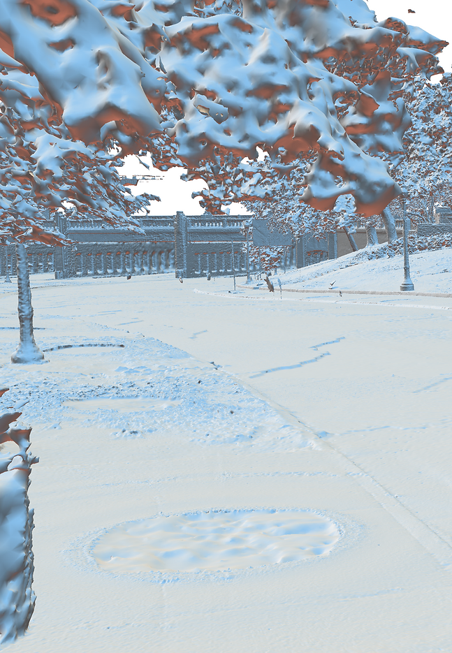
Captured with a forensic mindset
- Data was collected according to pre-calculated tolerances
- Automated flight plans are available for inspection
- Locations of interest (e.g. the Grassy Knoll) given priority in simulating historical lighting conditions
- Color calibration available for every ground image
- High quality GPS corrections collected for Post Processing Kinematics
- Manually laser measured control points at specific landmarks for confidence
- Full methodology, raw data and field notes available in data set
- Models are calculated for forensic consistency and accuracy, not aesthetics or results